DMI approach: helping municipalities master complex urban development
Municipalities have a huge task ahead of them: managing an array of urban development projects when space is scarce. As a result, it is becoming increasingly difficult to make spatial planning decisions that stand the test of time. Apeldoorn is no stranger to this challenge, with dozens of construction and infrastructure projects underway over the next five years. To reduce the impact on quality of life, the municipality is working with partners Goudappel, collaborall and TNO ‒ as part of the Dutch Metropolitan Innovation (DMI) ecosystem.
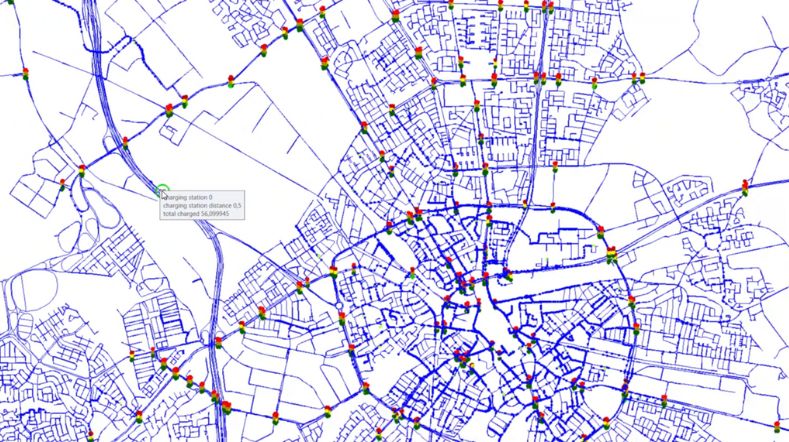
Digital twin Apeldoorn
Using digital twins for smart data sharing and scenario development makes the impacts both understandable and manageable, offering a practical blueprint that other municipalities can use as well.
With nearly 9,000 new homes being built by 2030, Apeldoorn is seeing its largest urban expansion in 40 years. This is part of the broader development in the Apeldoorn-Deventer-Zutphen triangle between 2030 and 2050, says the Municipality of Apeldoorn’s Chief Innovation Officer, Frans Jorna.
‘In the centre, we are combining urban densification with low-rise and high-rise buildings, mixed use, and a major investment in education. At the same time, we are making the city centre greener, with a central park providing access to the Veluwe forest. The increase in density, alongside road narrowing and greening, has sparked questions from the city council and residents alike. How do these plans affect liveability and accessibility in the city? What does cutting bus routes mean for transport poverty in surrounding villages? And how can we quantify and visualise these impacts? We didn’t have a way to steer the whole project, so we were in dire need of some guidance.’
Developing a steering mechanism
While the brief was clear, it presented a tremendous challenge, Frans explains. ‘The aim was to develop a steering mechanism to identify the bottlenecks and get around them ahead of time in four-week cycles. Digital twin models are essential to this task given how complex it is, but collecting, standardising, and exchanging data is a major hurdle ‒ and not just for Apeldoorn.’
Goudappel has been developing mobility models for the Municipality of Apeldoorn for years. In this case, though, it was about more than a single vision of the future, and emissions and liveability were also significant factors.
Frans continues: ‘Rapid and complex urban development calls for a dynamic monitoring and adjustment system, but our current information system and organisational structure just aren’t designed for that. It’s not only Apeldoorn struggling with this, but every medium-sized city in the Netherlands. So, should we leave each city to reinvent the wheel, or would it be better to find a common approach that works for us all?’
Blueprint for other municipalities
The answer came from working with partners in the Dutch Metropolitan Innovation (DMI) ecosystem, a National Growth Fund programme that aims to make it easier for governments and businesses to find, harness, and share data ‒ using new techniques in accordance with clear-cut rules.
The Municipality of Apeldoorn opted to collaborate with DMI partners Goudappel, collaborall and TNO for the very first time. Jacqueline Verbeek-Nijhof, Business Developer at TNO, says: ‘The great thing about collaborating under the DMI is that a lot of agreements are already in place, such as on data sharing and IP. This meant we could get straight down to business in Apeldoorn.’
'To make the data usable, Goudappel had to work with the municipality to collect, structure, and standardise all the information, and provide it with metadata. This was done by setting up a log for each project, containing contacts, schedules, and the streets involved.'
Clear steps to the process
To develop an approach that other DMI partners could also use, all the process steps were defined and standardised as much as possible. The first step was to gather information on the 40 or so construction and infrastructure projects that would start in the next five years. According to Peter Kleinjan, Managing Partner of data specialist collaborall, this information is fragmented and not standardised in many municipalities, Apeldoorn included.
‘To make the data usable, Goudappel had to work with the municipality to collect, structure, and standardise all the information, and provide it with metadata. This was done by setting up a log for each project, containing contacts, schedules, and the streets involved. All construction and infrastructure projects were then imported into the collaborall BuildHub, so that Goudappel could incorporate them into the traffic model.’
Calculating data at lightning speed
Goudappel faced a new complication, says Goudappel Mobility Twin Programme Director, Joost de Bruijn. ‘Rather than working with a straightforward traffic model featuring two years in the future and a handful of scenarios, we now had to navigate a full urban development process, taking multiple factors into account at once. This includes not only new housing developments and roads, but also ongoing road maintenance, events, and other factors that influence mobility.’
To place events more accurately in time, a system was needed that could read all the planning data and run the calculations quickly. Goudappel developed a sub-model that cuts out any unnecessary links and performs calculations that normally take half a day in just three minutes. ‘This model resulted in a series of scenarios: one per quarter for the next five years. We then shared the most critical scenarios with TNO, so they could determine and visualise the effects on quality of life.’
‘Taking the most critical scenarios from Goudappel, we used the TNO Predictive Digital Twin to see how this would affect accessibility and liveability in Apeldoorn city centre.’
An accident waiting to happen
Jacqueline continues: ‘Taking the most critical scenarios from Goudappel, we used the TNO Predictive Digital Twin to see how this would affect accessibility and liveability in Apeldoorn city centre.’
Still, disruption seemed unavoidable, even after project schedules were adjusted. Frans continues: ‘One quarter stood out: Q2 2026; it seemed like an accident waiting to happen.’
To prevent gridlock, the municipality worked with TNO to draw up four mitigating measures: reducing commuter traffic, adopting an alternative employer approach, moving transfer points to different locations, and adding shared mobility into the mix. But without a schedule of requirements, it was still unclear how these measures could be applied effectively. Using TNO’s Predictive Digital Twin, the actions were visualised in advance, allowing decision-makers to accurately determine where and when these measures would work best.
Looking at target groups
The next step in the collaboration has already been taken: a detailed determination of the impact that the measures would have on the various users of the city centre. Jacqueline continues: ‘The focus is shifting from system level to target group level. In Apeldoorn, we distinguish between three target groups: residents, visitors, and business owners. Together, we drew up indicators such as accessibility, traffic intensity, and noise pollution. That means we can now map out the specific impact that construction projects would have on different target groups.’
This target group approach produces different traffic model outcomes, notes Joost. ‘Typically, infrastructure is designed based on the morning and evening rush hour. But looking at business owners, for example, accessibility on Saturday afternoons is especially crucial. So, that changed the way we saw things and required us to adjust the model.’
Dashboard at target group level
To visualise the impact on the different target groups even further, TNO has also developed a dashboard based on the Predictive Digital Twin.
‘That dashboard instantly allows you to see the impact of mitigating measures on residents, visitors, and business owners’, Jacqueline explains. ‘What might be a good thing for a business owner might not work well for a resident. It provides a full perspective, from the big picture down to the detail. First we map out the problem and the measures we can take, and then we translate into different scenarios. The dashboard also immediately shows you what the effect of adjusting a scenario would be on the target groups. That way, you can come up with solutions that benefit everyone as much as possible.’
‘When two councillors asked about the impact that closing a road off somewhere would have on an alternative location, a traditional study with multiple scenarios would have taken months to compile. Now we can see the result in 40 seconds. And it helps us to uncover bottlenecks and gaps in our data that we would have otherwise missed.'
Intuition doesn’t cut it
What have the four partners got out of the collaboration so far? ‘First and foremost, a system that is technically unique’, Frans concludes, illustrating with a clear example.
‘When two councillors asked about the impact that closing a road off somewhere would have on an alternative location, a traditional study with multiple scenarios would have taken months to compile. Now we can see the result in 40 seconds. And it helps us to uncover bottlenecks and gaps in our data that we would have otherwise missed. Cyclists are the missing link here; they are crucial to reducing the number of cars and buses in the city centre. This approach gives us well-supported insights beyond the fuzzy logic that many officials now rely on.’
Joost agrees with Frans. ‘Our work is highly complex. Intuition alone is no longer enough; we need to do better. This project has shown us how important it is to bring all the data and models out of silos. We can’t do that without technology, or the client’s motivation and drive.’
Peter agrees: ‘Change is created by people who share a dream and a purpose. With this project, everything fell into place, and there was a huge motivation to get this done together.’
Demo at the Smart City Expo World Congress Barcelona
Goudappel, collaborall and TNO will be presenting the Apeldoorn case study in a demo at the Smart City Expo World Congress, from 4 to 6 November in Barcelona ‒ an easy way for representatives of municipalities to discover what this approach can do for them
For Jacqueline, there is no doubt that many municipalities will benefit from this kind of collaboration. ‘Many large and medium-sized cities are having or will have to deal with complex construction and infrastructure projects in the coming years, all of which raise questions about the city’s accessibility and liveability. The approach we’ve taken, with a reusable tool compatible with all existing GIS software, is easy to scale up to other municipalities, whether they are DMI partners or not. Instead of isolated solutions, we offer system solutions that factor in liveability, mobility, and accessibility. They no longer need to engage with all partners individually about their building requirements. This consortium rapidly calculates the most critical scenarios, outlines the most effective mitigation measures, and immediately shows the impact on different target groups. This gives municipalities the right insights to make the right choices even faster, together with residents and decision-makers.’
Contact us
-

Jacqueline Verbeek- Nijhof
Functie:Strategic Partnerships & Innovations-
Standplaats:Den Haag - New Babylon
-
Email:Email Jacqueline Verbeek-
-
Get inspired
TNO and Argaleo showcase next-generation real-time city simulation
Smarter and faster construction: TNO helps Eindhoven Metropolitan Region with historic leap of scale

Don't jump on every innovation bandwagon: TNO's framework to help cities make smarter mobility choices
Urban space

Zero emission urban mobility